- Reference
- Austral.Syst.Bot. 20:70 (2007)
- Conservation Code
- Not threatened
- Naturalised Status
- Native to Western Australia
- Name Status
- Current
Non-lignotuberous shrub or tree, 0.5-5(-8) m high. Fl. cream-yellow, Apr to Nov. Sand over limestone, laterite or granite, lateritic gravel.


Scientific Description
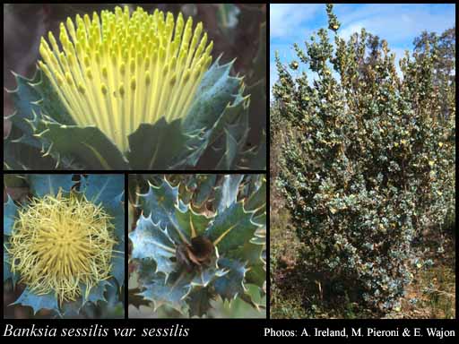
Shrubs, 2-4 m high; branchlets hairy. Leaves sessile, alternate, 20-40 mm long, 15-25 mm wide, hairy; lamina flat, clearly widest above the middle, once divided, pinnately divided, shallowly divided, teeth distinctly pointing towards the apex, with 3-7 lobes on each side, the margins flat. Inflorescences hirsute (with long, rough and coarse hairs), yellow; innermost bracts 8-10 mm long, hairy. Perianth 27-31 mm long, glabrous, without awns; pistil 25-30 mm long, straight, style glabrous. Follicles glabrous, pubescent (with soft, straight, erect hairs), ovate, 12-14 mm long. Flowers in May, June, July, August, September, October or November. Occurs in the South-west (SW) Botanical Province(s), in the Geraldton Sandplains (GS), Swan Coastal Plain (SWA), Avon Wheatbelt (AW), Jarrah Forest (JF), Mallee (MAL), Warren (WAR) or Esperance Plains (ESP) IBRA subregion(s).
Distribution
- IBRA Regions
- Avon Wheatbelt, Esperance Plains, Geraldton Sandplains, Jarrah Forest, Mallee, Swan Coastal Plain, Warren.
- IBRA Subregions
- Dandaragan Plateau, Fitzgerald, Geraldton Hills, Katanning, Merredin, Northern Jarrah Forest, Perth, Southern Jarrah Forest, Warren, Western Mallee.
- IMCRA Regions
- Leeuwin-Naturaliste, WA South Coast.
- Local Government Areas (LGAs)
- Albany, Armadale, Beverley, Boddington, Boyup Brook, Bridgetown-Greenbushes, Brookton, Broomehill-Tambellup, Bruce Rock, Busselton, Capel, Chapman Valley, Chittering, Collie, Corrigin, Cranbrook, Cuballing, Dandaragan, Donnybrook-Balingup, Dowerin, Dumbleyung, Gingin, Gnowangerup, Gosnells, Jerramungup, Kalamunda, Katanning, Kent, Kojonup, Kulin, Kwinana, Manjimup, Moora, Mundaring, Murray, Nannup, Narrogin, Northam, Pingelly, Plantagenet, Rockingham, Serpentine-Jarrahdale, Swan, Tammin, Toodyay, Victoria Plains, Wagin, Wandering, West Arthur, Wickepin, Williams, York.