- Reference
- Endl., Fenzl, Benth. & Schott, Enum.Pl. 36 (1837)
- Conservation Code
- Not threatened
- Naturalised Status
- Native to Western Australia
- Name Status
- Current
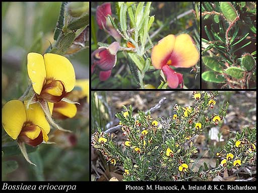
Erect or straggly & spreading shrub, 0.2-1 m high. Fl. yellow & brown/red, Jul to Nov. Usually on sandy soils.


Scientific Description
Genus Bossiaea. Form erect or prostrate,spreading or scrambling. Habit shrub, spindly shrub (broom-like). Stems Indumentum hairy, Pustules or glands absent, Striation (stems ribbed) not striate, Cross section terete, Spiny on any part of plant not spiny. Leaves or phylloclades Presence clearly present, Position alternate, Leaves simple, Leaves or phylloclade continuous with stem not continuous with stem, Cross section of leaf or leaflet flat with recurved margins, Margins of leaf or leaflet entire, Tuberculate tubercles absent, Pustules or glands absent. Length Leaf length 10-27. Width (entire leaves only) Leaf width 1.5-4. Scale leaves length mm long NaN (?). Indumentum Presence hairy, Type simple. Stipules Presence present and persistent to older leaves, Glands without glands, Ribs ribless. Length Stipule length 4-4.2. Bracteoles Presence present and persistent (?), absent (?) or present but early deciduous (?), Indumentum hairy (?) or glabrous (?), Striation striate (?) or not striate (?). Length Bracteole length NaN (?). Pedicel Presence present, Indumentum glabrous. Length Pedicel length 6-10. Calyx Pustules or glands absent, Ribs ribless, Enlarged in fruit not accrescent. Length Calyx length 6.4-8. Indumentum Presence hairy or glabrous, Type with simple hairs. Corolla Colour patterning multicoloured, Colour (when multicoloured - choose one colour) yellow, red or brown, Colour (when multicoloured - choose a second colour) yellow, red or brown, Petal claws ( the narrow base of the petals present. Length Corolla length 10-15. Indumentum Presence absent. Standard Indumentum glabrous, Auricles not auriculate. Length Standard length 9-14. Wings Auricles not auriculate. Length Wing length 8-12. Keel Auricles not auriculate, Indumentum glabrous, Beak not beaked. Length Keel length 9.5-12. Stamens Number ten. Anthers anther length 0.9-1, Position at two different levels (filaments alternately long and short). Filaments Fusion united in an open sheath. Length Filament length 7-11.5. Ovary Placement stipitate. Indumentum Presence glabrous. Style Indumentum glabrous, Bearded ( with a tuft of hairs at apex ) not bearded, Apex terete. Length Style length 10-11. Fruit Type dehiscent (a pod or follicle), Constriction not constricted between the seeds, Compression flat or compressed, Placement stipitate, Beak not beaked. Length Fruit length NaN (?). Width Fruit width NaN (?). Indumentum Presence hairy (?) or glabrous (?), Indumentum type with simple hairs (?) or with glandular hairs (?). Flowering time July, August, September, October or November. Distribution Botanical Province South-West, IBRA Bioregion Geraldton Sandplains, Avon Wheatbelt, Jarrah Forest, Warren, Esperance or Swan Coastal Plain.
Distribution
- IBRA Regions
- Avon Wheatbelt, Esperance Plains, Geraldton Sandplains, Jarrah Forest, Swan Coastal Plain.
- IBRA Subregions
- Dandaragan Plateau, Fitzgerald, Geraldton Hills, Katanning, Lesueur Sandplain, Merredin, Northern Jarrah Forest, Perth, Southern Jarrah Forest.
- IMCRA Regions
- Central West Coast, Leeuwin-Naturaliste.
- Local Government Areas (LGAs)
- Albany, Armadale, Bayswater, Beverley, Boyup Brook, Brookton, Broomehill-Tambellup, Bruce Rock, Bunbury, Busselton, Canning, Capel, Carnamah, Chapman Valley, Chittering, Cockburn, Collie, Coorow, Cottesloe, Cranbrook, Cuballing, Dandaragan, Dardanup, Donnybrook-Balingup, Dowerin, Dumbleyung, Gingin, Gosnells, Harvey, Irwin, Joondalup, Kalamunda, Katanning, Kellerberrin, Kojonup, Kwinana, Mandurah, Melville, Moora, Mundaring, Murray, Narrogin, Nedlands, Northam, Northampton, Perth, Pingelly, Plantagenet, Serpentine-Jarrahdale, Shark Bay, South Perth, Stirling, Swan, Tammin, Three Springs, Toodyay, Trayning, Victoria Plains, Wagin, Wandering, Wanneroo, Waroona, West Arthur, Williams, Wongan-Ballidu, Woodanilling, York.